Nedešćina
Municipality of Sveta Nedelja
In the eastern part of central Istria, on a high plateau above the Raša river valley and in the hinterland of the town of Labin, there is a special municipality of Sveta Nedelja.
The unique location, proximity to the sea, but also to lush forests, signifies a holistic green & blue combo, which represents a great potential for development and high quality of life for the residents of this area, as well as for numerous visitors.
This area is full of architectural remains that will tell you the story of the long and interesting history of this area and awaken the desire to explore and discover why in ancient times the rich chose this very area as the place to build their country estates.
Settlements
21 settlements are included in the municipality of Sveta Nedelja, namely: Cere, Eržišće, Frančići, Jurazini, Kraj Drage, Mali Golji, Mali Turini, Marići, Markoci, Nedešćina, Paradiž, Ružići, Santalezi, Snašići, Sveti Martin, Štrmac, Šumber, Veli Golji, Veli Turini, Vrećari, and Županići.
Larger settlements in the municipality of Sveta Nedelja are: Nedešćina (municipal centre), Štrmac, Šumber and Sveti Martin.
Population
According to the 2011 census, the Municipality of Sveta Nedelja has 3,158 inhabitants, and according to statistical data from 2019, it was recorded that 12,067 arrivals and 110,266 overnight stays were made in the Municipality of Sveta Nedelja. This information indicates how the municipality of Sveta Nedelja has become a desirable destination.
Geographical location
Sveta Nedelja is located on a plateau, at a height of 250 to 300 meters above sea level, which stretches from the Raša river to the sea in the hinterland of the town of Labin. River Raša flows alongside the western border of the municipality separating the central and eastern parts of Istria. The sea is only ten kilometres away in Rabac, so this unique area is in a way a bridge between the Green and Blue Istria.
Climate
Sveta Nedelja is located at the intersection of the Mediterranean and continental climates with the interesting marine influences of the Raša River valley and the Plomin Bay. Although they are geographically located inland, the places that are under a greater influence of Raša and the Plomin Bay enjoy a climate with Mediterranean features where vegetation that requires a milder climate thrives, while it is too cold for Mediterranean vegetation (olives, for example). On the other hand, places that are located in higher areas or in the shade have pronounced characteristics of the sub-Mediterranean climate, which will mean that the winters are harsher and the summers are milder than by the sea. That is why this is an exceptional place to enjoy the sea, but at the end of the day perfect for retreating to the shade of the interior, which offers gentle winds, cooler nights and more frequent refreshing summer rains.
During winter, temperatures drop below zero and late spring frosts can occur, while snow is very rare. In winter, this area often experiences bura, a cold and dry northern wind that blows from the mountains and inland towards the sea. Spring and autumn are rainy periods with the occasional appearance of longer periods of more stable weather and it can be very foggy in places, and autumn is characterized by the peculiarity of the southern wind or jugo that brings fog, warmer and more humid weather, and gloomy skies. Summers are warm, clear and mostly dry, and the amount of precipitation increases proportionately as you move inland from the sea.
Vegetation
The vegetation in this area is typically sub-Mediterranean and the landscape alternates between arable land with grassland and with forest vegetation as a reflection of the different type of soil and climate. The forests are dominated by deciduous species including oak, ash tree and sweet chestnut. In the areas located on the edges of the exploitation fields, ruderal vegetation typical of the habitats near the quarry has developed, such as rosemary-leaved cypress (Epilobium dodonaei) and large plantain (Plantago major). The forest vegetation along the slopes of the Raša canyon is characterized by medium-high vegetation and bushes, and low trees.
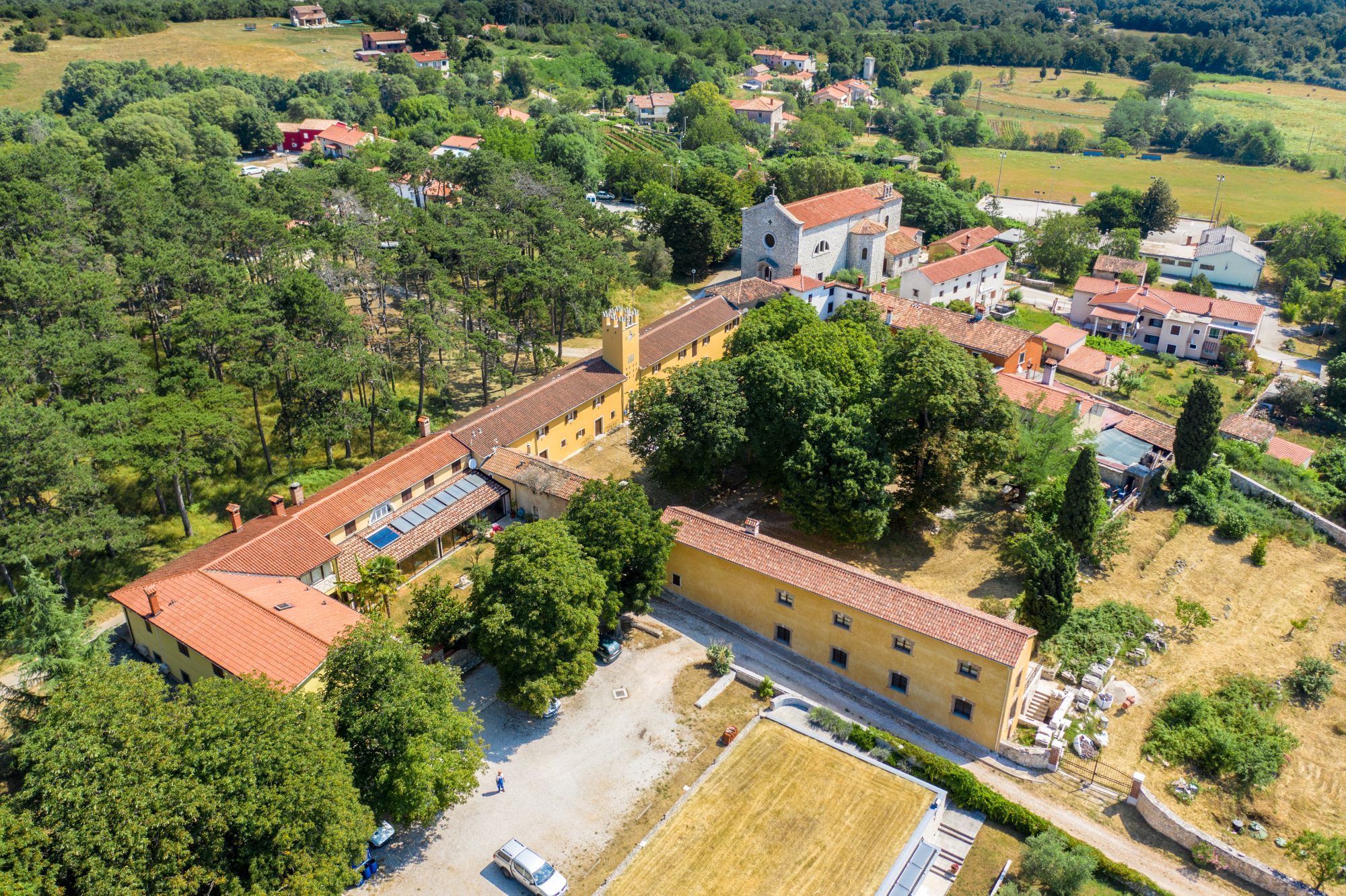
It is also important to mention the park in Nedešćina, which is located around the former Villa Furlani, today the Home for Adults "Sv. Nedelja", which has a unique plant inventory and was declared a monument of park architecture back in 1974.
Although the park is currently quite neglected, it is still home to interesting plant species such as: laurel (Laurus nobilis), Lebanese cedar (Cedrus libani), paulownia (Paulownia tomentosa), cypress (Cupressus sempervirens), acacia (Robinia pseudacacia), wild chestnut (Aesculus hippocastanum), black pine (Pinus nigra), Judas tree (Cercis siliquastrum), elm (Ulmus), Greek fir (Abies pinsapo), yew (Taxus baccata), white poplar (Populus alba), hornbeam (Carpinus orientalis) , hornbeam (Ostrya carpinifolia), sycamore (Platanus orientalis),and oak (Quercus pubescens).
History
The history of Istria, and thus of this region, is long and turbulent, which is easily understandable considering the geographical position at the crossroads of forces that were located east and west of Istria, and due to the proximity of the sea and trade interests intertwined with controlling sea routes.
The area of Sveta Nedelja was first inhabited in the Bronze Age, when Illyrian-Celtic tribes built kašteljeri (hillforts) or prehistoric forts on hills. In the 4th century BC the Celts founded Labin (Alvona or Albona) and the nearby Plomin (Flanona), and a few hundred years later, in 177 BC when the Romans came to power in Istria, the river Raša became the border between the territory of the Liburnians (Illyrian tribe) and the Romans. Albona was an important ancient centre of a wider area, and in the 8th century, Charlemagne founded the Friuli marque and separated Labin from Liburnia.
The development of the village in the hinterland of Labin over the Raša canyon is closely connected with the properties of the Aquileian patriarchs, that is, later German nobles in this area. With the strengthening of feudalism, the autonomy of the cities decreased so that the surrounding estates came into the possession of various noble families from Germany during the 9th and 10th centuries. The patriarchs of Aquileia again become the leaders of the Labin area from 1207 to 1420, and in this period Labin develops into a free city. At that time, feudal estates such as the castle in Šumber were developed in the hinterland of Labin.
After 1420 and the fall of Aquileia, Labin and Plomin came under the Venetian administration. The economy of this area was tied to the large feudal estates in the surroundings that were managed by the noble families of Labin, and in the 16th and 17th centuries, the palaces of the old town of Labin and castles with surrounding buildings were built in the hinterland. At that time, new parishes were created in the smaller settlements of present-day Nedešćina, Sveta Nedelja and Sveti Martin.
The real development of this area comes with the beginnings of mining in the 19th century, under French and then Austrian administration. In the area of Sveta Nedelja, a mining shaft is opened in Štrmac, next to which a new, small mining settlement emerges. In the 19th century, the local centre and place for holding fairs and other events, Sveta Nedelja, strengthened and grew, a place that was located next to the medieval Benedictine abbey of the Holy Trinity, whose traces are no longer present. At that time, a large new church was built and formed the centre of the town with a spacious square, and until the 20th century the whole area experienced a revival due to industrial production and mining. However, the huge reduction of mining activities in the 1970s and 1980s also meant the introduction of changes in the way of life of the people of this region, who had to turn to other branches of the economy.